


US Topo Maps
US Topo Maps介绍
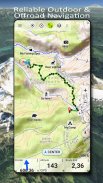
易于使用的户外导航应用程序,可免费访问美国最好的地图和航空图像。
在 30 多个地图图层(地形图、航空图、海图……)中进行选择来规划完美的旅行并
将您的 Andoid 手机/平板电脑变成户外 GPS,以便离线前往野外旅行。
轻松添加其他来源的地图(GeoPDF、GeoTiff、WMS 等在线地图服务……)
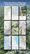
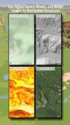
美国可用的底图图层:
• 美国地质勘探局国家地图地形
• USGS 国家地图图像地形
• USGS 国家地图图像
• USGS NAIP 高分辨率图像
• USGS 地形传统 DRG:无缝覆盖比例尺为 1:250.000、1:100.000、1:63.000 和 1:24.000/25.000 的美国地形图
• FSTOpo 森林地图
• NOAA 航海 RNC 海图
• 国家高程图(山体阴影、坡度图、坡向图)
全球底图图层:
• OpenStreetMaps(5 种不同的地图布局),也可以以节省空间的矢量格式下载
• Google 地图(卫星图像、道路和地形图)
• Bing 地图(卫星图像、路线图)
• 夜晚的地球
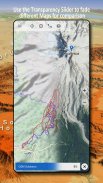
将底图图层配置为叠加层,并利用透明度推子来无缝地相互比较地图。
添加其他来源的地图:
• 在 GeoPDF、GeoTiff、MBTiles 或 Ozi (Oziexplorer OZF2 & OZF3) 中导入栅格地图
• 添加网络地图服务作为 WMS 或 WMTS/Tileserver
• 以矢量格式导入 OpenStreetMap,例如仅需要几 GB 的完整美国
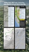
可用的美国地图叠加 - 将附加信息添加到任何其他底图:
• 公共土地所有权 (PAD-US 3)
• 国家水文数据集
• 机动车辆使用地图(美国农业部)
• 等高线
• 四轮驱动步道
• 步道
• 公路、铁路、机场
全球可用覆盖:
• 山体阴影叠加
• 20m 轮廓线
• 开放海洋地图
没有完美的地图。在不同地图图层之间切换或使用比较地图功能来查找最有趣的路线。特别是旧的传统 DRG 包含许多现代地图上缺少的小路径或其他特征。
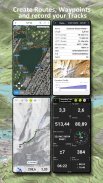
户外导航的主要特点:
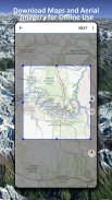
• 下载地图数据以供离线使用
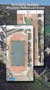
• 测量路径和面积
• 创建和编辑航点
• GoTo 航点导航
• 创建和编辑路线
• 路线导航(点对点导航)
• 轨迹记录(包括速度、海拔和精度曲线)
• Tripmaster 包含里程表、平均速度、方位、海拔等字段。
• GPX/KML/KMZ 导入/导出
• 搜索(地名、兴趣点、街道)
• 获取海拔和距离
• 地图视图和 Tripmaster 中的可自定义数据字段(例如速度、距离、指南针……)
• 共享航点、轨迹或路线(通过电子邮件、Dropbox、WhatsApp、..)
• 使用 WGS84、UTM 或 MGRS/USNG(军事网格/美国国家网格)中的坐标,
• 曲目重播
• 还有很多 ...
使用此导航应用程序进行户外活动,如远足、骑自行车、露营、攀岩、骑马、滑雪、划独木舟、打猎、雪地摩托之旅、越野四驱车之旅或搜救 (SAR)。
使用 WGS84 基准添加经度/纬度、UTM 或 MGRS/USNG 格式的自定义航路点。
以 GPX 或 Google Earth KML/KMZ 格式导入/导出/共享 GPS 航点/轨迹/路线。
查看动画 NEXRAD 降雨雷达,准确预测降雨何时开始/停止
请将问题、意见和功能请求发送至 support@atlogis.com
US Topo Maps - 版本7.8.0
(08-05-2025)US Topo Maps - APK信息
APK版本: 7.8.0程序包: com.atlogis.northamerica.freeUS Topo Maps的最新版本
其他版本


同类应用


